Many historic concrete mile posts are still in place beside railroad tracks (BMRR and other railroad companies). The number on a mile post was the distance the BEGINNING of that railroad (beginning of a mainline or beginning of a branch) was from the headquarters of that railroad company (for example, the various BMRR branches in Alabama began the numbering of the mile posts for that branch based on how far the beginning of that branch was from the L&N headquarters in Louisville, Kentucky). (In addition to the Mile Post information presented here, there is a map of ALL the known mile posts in the United States at this USDOT link.)
The BMRR Signs Project is adding Mile Post interpretive signs near historic mile posts (no matter what railroad company the post belonged to) in locations where people will see them and will learn about the purpose of the mile posts. This web page lists the locations of the Mile Post interpretive signs that have been installed thus far (and possible other locations) — see below. A MAP of the locations of the installed Mile Post interpretive signs (BLACK railroad track symbols on the map) AND other known Mile Posts that are visible from public property but that do NOT yet have interpretive signage are listed below and on the map at this link. (RED railroad track symbols on that map). Contact us if you know of other Mile Posts where we can consider putting interpretive signs — no matter what railroad.
The wording of the interpretive signs is as follows:
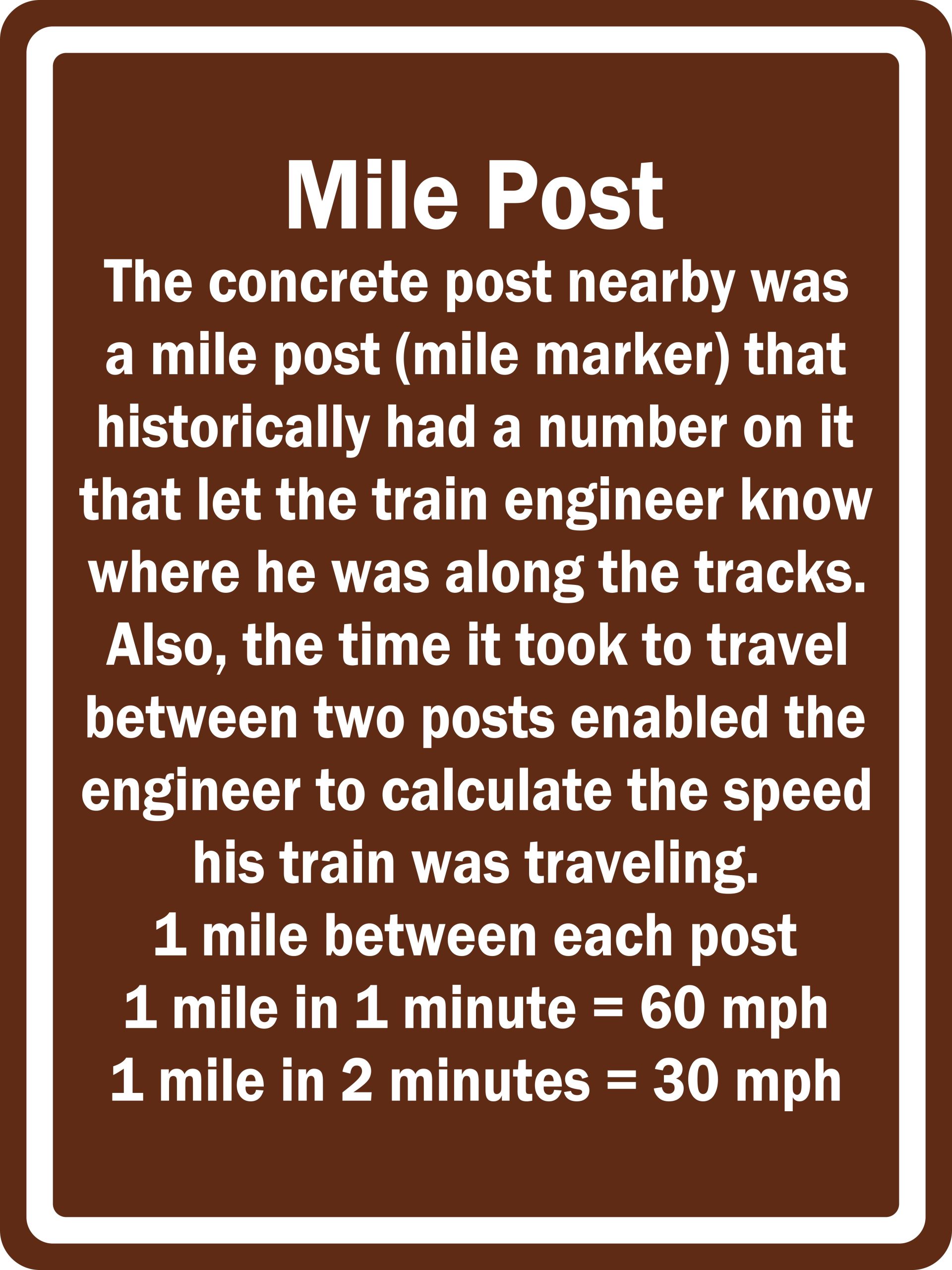 Mile Post
The concrete post nearby was a mile post (mile marker) that historically had a number on it that let the train engineer know where he was along the tracks. Also, the time it took to travel between two posts enabled the engineer to calculate the speed his train was traveling.
1 mile between each post
1 mile in 1 minute = 60 mph
1 mile in 2 minutes = 30 mph
SOURCES FOR FINDING MILE POST LOCATIONS:
— US Department of Transportation Mile Posts website at
https://datahub.transportation.gov/Railroads/Rail-Mileposts/q97d-bh4x
— Google Earth
— On-site reconnaissance
— Research by members of the Mid-South Chapter of the Railway & Locomotive Historical Society and by volunteers at Heart of Dixie Railroad Museum often using historic railroad employee timetables.
Locations of ALREADY INSTALLED Mile Post interpretive signs are in the following list. See the MAP for specific locations (BLACK railroad track symbols on the map). (A list of other Mile Post locations and possible interpretive sign locations follows this list of already installed interpretive signs.) All locations are in Alabama, unless otherwise indicated. NOTE: Any addresses shown in descriptions are for ease of finding the Mile Post and must not be used for any other purposes.
1. Birmingham — Vulcan Trail (Kiwanis Vulcan Trail) near mid-point of paved portion; east of big concrete mine tipple foundation beside trail. Mile Number 400. Latitude/Longitude: N 33 29 23.6 W 86 48 2.7 Decimal Degrees: 33.489889, -86.80075 RAILROAD COMPANIES: Historically, Birmingham Mineral Railroad Red Gap Branch (part of Louisville & Nashville Railroad); currently abandoned.
2. Trafford — Warrior-Trafford Road — North side of Trafford Memorial Park (near street crossing of active railroad tracks). Mile Number 368. Latitude/Longitude: N 33 49 12.24 W 86 44 35.21 Decimal Degrees: 33.820067, -86.743114 RAILROAD COMPANIES: Historically, South & North Alabama Railroad which became part of Louisville & Nashville Railroad (mainline from Louisville, Kentucky, to Mobile, Alabama); currently CSX.
3. Fultondale — Walking/Bicycling Cain Creek Trail (often currently referred to as “Cane Creek”) part of Fivemile Creek Greenway of the Red Rock Trail System — Beside trail east of entrance at Stouts Road. Louisville & Nashville Railroad (BMRR) Mile Number 365. Latitude/Longitude: N 33 37 17 W 86 48 7 Decimal Degrees: 33.621389, -86.801944 RAILROAD COMPANIES: Historically, Birmingham Mineral Railroad Cain Creek Branch (part of Louisville & Nashville Railroad); currently abandoned.
4. Fultondale — Walking/Bicycling Cain Creek Trail (often currently referred to as “Cane Creek”) part of Fivemile Creek Greenway of the Red Rock Trail System — Beside trail one-fourth mile east of trail entrance at Shady Grove Road. Mile Number (number no longer on post). Latitude/Longitude: N 33 37 43.36 W 86 50 56.47 Decimal Degrees: 33.628711, -86.849019 RAILROAD COMPANIES: Historically, Birmingham Mineral Railroad Cain Creek Branch (part of Louisville & Nashville Railroad); currently abandoned.
5. Gardendale — Walking/Bicycling Cain Creek Trail (often currently referred to as “Cane Creek”) part of Fivemile Creek Greenway of the Red Rock Trail System — Beside trail one-fourth mile east of trail entrance at Fieldstown Road. Mile Number 389. Latitude/Longitude: N 33 37 50.33 W 86 51 53.78 Decimal Degrees: 33.630647, -86.864939 RAILROAD COMPANIES: Historically, Birmingham Mineral Railroad Cain Creek Branch (part of Louisville & Nashville Railroad); currently abandoned.
6. Bessemer — 21st Street North. The currently active CSX railroad tracks near this sign are on the original BMRR roadbed. Mile Number 403. Latitude/Longitude: N 33 24 15.93 W 86 57 3.947 Decimal Degrees: 33.404425, -86.951096 RAILROAD COMPANIES: Historically, Birmingham Mineral Railroad North Branch (part of Louisville & Nashville Railroad); currently CSX.
7. Pelham — County Road 52 (Highway 52) across the road from the “tank farm” entrance. This triangular mile post number 959 indicates the distance from Richmond, Virginia. Also on one side of the post is D 427. Latitude/Longitude: N 33 16 54.35 W 86 48 17.7 Decimal Degrees: 33.281764, -86.804917 RAILROAD COMPANIES: Historically, Atlanta Birmingham & Atlantic; Atlanta Birmingham & Coast; Atlantic Coast Line; Seaboard Coast Line; Seaboard System; currently CSX.
8. Tarrant — Springdale Road at the active railroad tracks that originally were the BMRR tracks. Mile Number 391. Latitude/Longitude: N 33 35 42.9972 W 86 46 11.92 Decimal Degrees: 33.595277, -86.769978 RAILROAD COMPANIES: Historically, Birmingham Mineral Railroad Huntsville Branch No. 2 (part of Louisville & Nashville Railroad); currently CSX.
9. Hartselle — US Highway 31 at intersection of Cedar Creek Church Road (aka Cedar Creek Road). Beside currently active CSX tracks. Mile Number 323. Latitude/Longitude: N 34 24 4.78 W 86 54 47.66 Decimal Degrees: 34.401328, -86.913239 RAILROAD COMPANIES: Historically, South & North Alabama Railroad which became part of Louisville & Nashville Railroad (mainline from Louisville, Kentucky, to Mobile, Alabama); currently CSX.
10. Falkville — US Highway 31 seven tenths of a mile south of intersection of West Piney Grove Road. Beside currently active CSX tracks. Mile Number 327. Latitude/Longitude: N 34 20 41.9 W 86 54 19.8 Decimal Degrees: 34.344972, -86.9055 RAILROAD COMPANIES: Historically, South & North Alabama Railroad which became part of Louisville & Nashville Railroad (mainline from Louisville, Kentucky, to Mobile, Alabama); currently CSX.
11. Garden City — Railroad Avenue N just north of intersection of 3rd Street SE. Beside currently active CSX tracks. Mile Number 353. Latitude/Longitude: N 34 0 47.22 W 86 4 59.4 Decimal Degrees: 34.013117, -86.083167 RAILROAD COMPANIES: Historically, South & North Alabama Railroad which became part of Louisville & Nashville Railroad (mainline from Louisville, Kentucky, to Mobile, Alabama); currently CSX.
12. Lipscomb — Avenue H in downtown Lipscomb in the linear park that runs beside the active CSX tracks. Mile Number 401. Latitude/Longitude: N 33 25 38.64 W 86 55 20.02 Decimal Degrees: 33.4274, -86.922228 RAILROAD COMPANIES: Historically, Birmingham Mineral Railroad North Branch (part of Louisville & Nashville Railroad); currently CSX.
13. Helena — Lee Springs Park. Installed by Helena Historic Preservation Committee beside Hillsboro walking trail in Lee Springs Park. NOTE: This interpretive sign has different signage and wording than the regular interpretive signs indicated above because it was designed to be the same as other interpretive signs in Lee Springs Park. Mile Number 409. Latitude/Longitude: N 33 17 36.095 W 86 51 24.335 Decimal Degrees: 33.29336, -86.85676 RAILROAD COMPANIES: Historically, Birmingham Mineral Railroad Helena and Blocton Branch (part of Louisville & Nashville Railroad); currently abandoned.
14. Pelham — County Highway 52 W — Installed near intersection of Lee Street. Beside currently active CSX tracks. Mile number 411. Latitude/Longitude: N 33° 17′ 9.3948″ W 86° 48′ 51.462″ Decimal Degrees: 33.285943, -86.814295 RAILROAD COMPANIES: Historically, South & North Alabama Railroad which became part of Louisville & Nashville Railroad (mainline from Louisville, Kentucky, to Mobile, Alabama); currently CSX.
15. Alabaster — 1st Street SW — Installed beside 1st Street SW near intersection of 2nd Avenue SW. Mile number 414. Beside currently active CSX tracks. Latitude/Longitude: N 33° 14′ 34.62″ W 86° 49′ 1.581″ Decimal Degrees: 33.24295, -86.817106 RAILROAD COMPANIES: Historically, South & North Alabama Railroad which became part of Louisville & Nashville Railroad (mainline from Louisville, Kentucky, to Mobile, Alabama); currently CSX.
16. Millbrook — Installed on entrance sign to Jackson Lake Island on Cypress Lane. Mile number 483. Beside currently active CSX tracks on west side of tracks. Latitude/Longitude: N 32° 26′ 44.685″ W 86° 20′ 18.9924″ Decimal Degrees: 32.4457461, -86.3386095 RAILROAD COMPANIES: Historically, South & North Alabama Railroad which became part of Louisville & Nashville Railroad (mainline from Louisville, Kentucky, to Mobile, Alabama); currently CSX.
17. Elmore — Jackson Street — Installed near intersection of Hatchett Street. Mile number 476. Beside currently active CSX tracks. Latitude/Longitude: N 32° 32′ 35.4402″ W 86° 18′ 53.3946″ Decimal Degrees: 32.5431780, -86.3148319 RAILROAD COMPANIES: Historically, South & North Alabama Railroad which became part of Louisville & Nashville Railroad (mainline from Louisville, Kentucky, to Mobile, Alabama); currently CSX.
18. Jemison — Ellison Road — Installed near intersection of Ellison Lane. Mile number 437. Beside currently active CSX tracks. Latitude/Longitude: N 32° 56′ 39.0114″ W 86° 44′ 17.322″ Decimal Degrees: 32.9441697, -86.7381448 RAILROAD COMPANIES: Historically, South & North Alabama Railroad which became part of Louisville & Nashville Railroad (mainline from Louisville, Kentucky, to Mobile, Alabama); currently CSX.
19. Birmingham — 33rd Street North — Mile Post visible from 33rd Street North. Mile Post is near where 33rd Street North deadends at railroad tracks. Mile number 389. Latitude/Longitude: 33° 33′ 9.14796″ W 86° 48′ 1.5415″ Decimal Degrees: 33.55254, -86.80043 RAILROAD COMPANIES: Historically, Birmingham Mineral Railroad Huntsville Branch No. 1 (part of Louisville & Nashville Railroad); currently CSX.
20. Birmingham (Pratt City) — Avenue U in Pratt City north of 6th Street intersection at active CSX tracks. Mile number 394. Latitude/Longitude: N 33 31 42.54168 W 86 52 50.8296 Decimal Degrees: 33.52845, -86.88075 RAILROAD COMPANIES: Historically, Birmingham Mineral Railroad Huntsville Branch No. 1 (part of Louisville & Nashville Railroad); currently CSX.
21. Birmingham — 6th Street South in curve at 7th Avenue South — Mile Post is beside 6th Street South (north of intersection of Greensprings Highway). Mile number 393. Beside currently active CSX tracks. Latitude/Longitude: N 33° 29′ 48.192″ W 86° 49′ 8.4″ Decimal Degrees: 33.49672, -86.81903 RAILROAD COMPANIES: Historically, Birmingham Mineral Railroad North Branch (part of Louisville & Nashville Railroad); currently CSX.
22. Horse Cave, Kentucky — US Highway 31W (North Dixie Street). Beside US Highway 31W (across the road from 650 N Dixie Street). Mile number 80. Beside active CSX tracks. Latitude/Longitude: N 37° 11′ 20.1474″ W 85° 53′ 53.196″ Decimal Degrees: 37.18893, -85.89811 RAILROAD COMPANIES: Historically, Louisville & Nashville Railroad (mainline from Louisville, Kentucky, to Mobile, Alabama); currently CSX.
23. New Haven, Kentucky, at Kentucky Railway Museum — Beside former Louisville & Nashville Railroad tracks on the grounds of the Kentucky Railway Museum where historic train cars are displayed. Mile number 45. From the museum’s letter of acknowledgement: “On behalf of the Kentucky Railway Museum’s Board of Directors, Members, and Staff, please accept our sincere thanks and appreciation for your kind and very generous donation of a sign explaining about mile posts. Your contribution will help to continue the work of this museum in interpreting the story, past, present, and future of Kentucky’s railroads and people as a major part of the Commonwealth’s growth and development.” Latitude/Longitude: N 37° 39′ 23.95152″ W 85° 35′ 30.35868″ Decimal Degrees: 37.6566532, -85.5917663 RAILROAD COMPANIES: Historically, Louisville & Nashville Railroad (mainline from Louisville, Kentucky, to Mobile, Alabama); currently used by Kentucky Railway Museum to display historic train cars and next to active tracks used for excursion rides.
24. Montgomery — N Court Street north of where tracks cross the street at N Railroad Street. Mile number 175 (triangular post). Latitude/Longitude: N 32° 23′ 13.4718″ W 86° 18′ 34.227″ Decimal Degrees: 32.38708, -86.30951 RAILROAD COMPANIES: Historically, Montgomery to Franklin, Alabama, Railroad; Montgomery Railroad; Montgomery and West Point Railroad; Western Railroad of Alabama; Western Railway of Alabama; Seaboard System Railroad; currently CSX.
25. Thorsby — Montgomery Avenue. Mile number 439. Beside currently active CSX tracks. Latitude/Longitude: N 32° 55′ 16.55076″ W 86° 43′ 11.29008″ Decimal Degrees: 32.92126, -86.7198 RAILROAD COMPANIES: Historically, South & North Alabama Railroad which became part of Louisville & Nashville Railroad (mainline from Louisville, Kentucky, to Mobile, Alabama); currently CSX.
26. Thorsby — Sam Bentley Park at softball field. Mile number 440. Beside currently active CSX tracks. Latitude/Longitude: N 32° 54′ 26.68572″ W 86° 42′ 33.46668″ Decimal Degrees: 32.90741, -86.7093 RAILROAD COMPANIES: Historically, South & North Alabama Railroad which became part of Louisville & Nashville Railroad (mainline from Louisville, Kentucky, to Mobile, Alabama); currently CSX.
27. Tarrant — Black Creek Road near railroad signaling structure above tracks. Mile number 384. Latitude/Longitude: N 33° 36′ 43.6896″ W 86° 46′ 46.5996″ Decimal Degrees: 33.612136 -86.779611 RAILROAD COMPANIES: Historically, Louisville & Nashville Railroad; currently CSX.
28. Georgiana — West Railroad Avenue beside currently active CSX tracks. (“Restored” caboose visible in next block down West Railroad Avenue at Hank Williams Museum.) Mile number 547. Latitude/Longitude: N 31° 38′ 25.755792″ W 86° 44′ 26.241648″ Decimal Degrees: 31.64048772 -86.74062268 RAILROAD COMPANIES: Historically, Louisville & Nashville Railroad; currently CSX.
29. Atmore — Swift Mill Road beside currently active CSX tracks. Mile number 623. Latitude/Longitude: N 31° 1′ 24.384288″ W 87° 30′ 59.954364″ Decimal Degrees: 31.02344008 -87.51665399 RAILROAD COMPANIES: Historically, Louisville & Nashville Railroad; currently CSX.
The following list documents other known Mile Post locations that can be seen from public property, and interpretive signs may be installed later at some of those locations. See the MAP for specific locations (RED railroad track symbols on the map). All locations are in Alabama, unless otherwise indicated.
Birmingham — 27th Street North (below street overpass) — Mile Post visible from 27th Street North.
No interpretive sign installed. Mile Post can be seen in the distance looking west from 27th Street North. Mile Post number 390. BMRR Huntsville Branch Number 1. Decimal Degrees: 33.55047, -86.81694
Birmingham — Montevallo Road (Martin Luther King Jr Drive) — Mile Post beside Montevallo Road.
INTERPRETIVE SIGN MAY BE INSTALLED LATER. Mile Post is where street crosses railroad tracks. Mile Post number 395. BMRR North Branch. Decimal Degrees: 33.47465, -86.84023
Birmingham — 31st Street SW near Cedar Avenue — Mile Post NOT Close to Street.
No interpretive sign installed. Mile Post number 398 visible on right side of tracks with a whistle post beside it. BMRR North Branch. Decimal Degrees: 33.45707, -86.88348
Birmingham — Mineral Avenue SW near Willard Street — Mile Post visible from Mineral Avenue SW.
INTERPRETIVE SIGN MAY BE INSTALLED LATER. Mile Post number 399. BMRR North Branch. Decimal Degrees: 33.44811, -86.89893
Birmingham — Allen Avenue (Alley) in southwest Birmingham — Mile Post visible from Allen Avenue (Alley). No interpretive sign installed. Mile Post number 400 visible on left side of tracks. Overpass in distance is former High Line tracks, now High Ore Line Trail. BMRR North Branch. Decimal Degrees: 33.43784, -86.91069
Alabaster — Industrial Road west of Highway 31 intersection — No interpretive sign installed. Mile Post number 413 visible on left side of tracks looking north with a whistle post nearby. Beside former Louisville & Nashville Railroad tracks, currently active CSX tracks. Decimal Degrees: 33.25679, -86.81464
Clanton — Highway 47. Mile Post visible from Highway 47. No interpretive sign installed. Mile Post number 450 visible on left side of tracks. Beside former Louisville & Nashville Railroad tracks, currently active CSX tracks. Decimal Degrees: 32.80492, -86.59732
Clanton — 18490 US Highway 31. Mile Post barely visible from US Highway 31. No interpretive sign installed. Mile Post number 442. Beside former Louisville & Nashville Railroad tracks, currently active CSX tracks. Decimal Degrees: 32.8923062, -86.6816293
Clanton — 17580 US Highway 31. Mile Post visible from US Highway 31 close to signal box. No interpretive sign installed. Mile Post number 443. Beside former Louisville & Nashville Railroad tracks, currently active CSX tracks. Decimal Degrees: 32.8849427, -86.6667773
Elmore — 1060 Coosada Parkway. No interpretive sign installed. Mile Post number 478. Beside former Louisville & Nashville Railroad tracks, currently active CSX tracks. Decimal Degrees: 32.5139379, -86.3249923
Helena — Beside park entrance in Old Town Helena. Beside currently active CSX tracks. Mile Post number 409. Latitude/Longitude: N 33 17 47.2 W 86 50 37.2 Decimal Degrees: 33.296444, -86.843667 RAILROAD COMPANIES: Historically, South & North Alabama Railroad which became part of Louisville & Nashville Railroad (mainline from Louisville, Kentucky, to Mobile, Alabama); currently CSX.
Jefferson County Unincorporated — North of Tarrant — Meadow Craft Road — No interpretive sign installed. Mile Post number 395 visible on left side of tracks looking south. BMRR Huntsville Branch No. 2. Decimal Degrees: 33.6429, -86.72879
Jemison — 2628 Ellison Road (dirt portion) near US Highway 31. Mile Post barely visible from US Highway 31. No interpretive sign installed. Mile Post number 438. Beside former Louisville & Nashville Railroad tracks, currently active CSX tracks. Decimal Degrees: 32.931182, -86.7306114
Millbrook — 1497 Coosada Parkway. No interpretive sign installed. Mile Post number 481. Beside former Louisville & Nashville Railroad tracks, currently active CSX tracks. Decimal Degrees: 32.4744282, -86.342062
Millbrook — 814 Railroad Street. No interpretive sign installed. Mile Post number 482. Beside former Louisville & Nashville Railroad tracks, currently active CSX tracks. Decimal Degrees: 32.4599807, -86.3440608
Oneonta — Near US Highway 231. INTERPRETIVE SIGN MAY BE INSTALLED LATER. On site of former Champion Mine. PRIVATE PROPERTY — do not enter without permission of the owner. Mile Post number 424. BMRR Huntsville Branch No. 2.
Tarrant — Thomason Avenue — No interpretive sign installed. Mile Post number 390 visible on left side of tracks looking south. BMRR Huntsville Branch No. 2. Decimal Degrees: 33.58342, -86.77817
Tarrant — 3rd Avenue and 10th Street — No interpretive sign installed. Mile Post number 393 visible on right side of tracks looking north. BMRR Huntsville Branch No. 2. Decimal Degrees: 33.58342, -86.77817
Thorsby — US Highway 31 at 3rd Street. No interpretive sign installed. Mile Post number 441. Beside former Louisville & Nashville Railroad tracks, currently active CSX tracks. Decimal Degrees: 32.8995972, -86.6962931
Horse Cave, Kentucky — US Highway 31W (North Dixie Street). Beside US Highway 31W (North Dixie Street). No interpretive sign installed. Mile Post number 79. Beside former Louisville & Nashville Railroad tracks, currently active CSX tracks. Decimal Degrees: 37.19689, -85.88731